My Cart
Your Cart 0

    Your cart is empty.

  • Total (Amount) ₹0.00
Previous year question hub

Remote Sensing and Image Processing - Data Analysis, Remote Sensing and Geo-informatics - Architecture and Planning Previous Year Questions

Practice Remote Sensing and Image Processing - Data Analysis, Remote Sensing and Geo-informatics - Architecture and Planning previous year questions organised from real papers, with year-wise coverage and clear topic navigation.

8Papers
8Years
13Questions
1Topics

Remote Sensing and Image Processing question pattern

Every graph below is calculated only from this selection.

Questions by year

Compare question counts across years.

Difficulty distribution

How the classified questions are distributed by difficulty.

Easy 8 61.5%
Medium 4 30.8%
Hard 1 7.7%

Question type distribution

MCQ, numerical, multiple-select and other formats found in these papers.

MCQ 11 84.6%
MSQ 2 15.4%

Subject weightage

Top subjects by unique question coverage.

Architecture and Planning
13 Qs

Most asked topics

Top topics across the included previous year papers.

Data Analysis, Remote Sensing and Geo-informatics
13 Qs

Subtopic coverage

Top subtopics inside this exact selection.

Remote Sensing and Image Processing
13 Qs

Paper coverage

Question coverage for the most populated papers. Every active PYP paper remains listed below.

Architecture and Planning (AR) 2026
2 Qs
Architecture and Planning (AR) 2025
1 Qs
Architecture and Planning (AR) 2023
2 Qs
Architecture and Planning (AR) 2021
1 Qs
Architecture and Planning (AR) 2017
1 Qs
Architecture and Planning (AR) 2009
2 Qs
Architecture and Planning (AR) 2008
2 Qs
Architecture and Planning (AR) 2007
2 Qs

Included previous year papers

Newest papers appear first. Search these papers or sort by year and name.

Paper nameYearPDFAttempt
Architecture and Planning (AR) 20262026
2 questions in this view
2026
Architecture and Planning (AR) 20252025
1 questions in this view
2025
Architecture and Planning (AR) 20232023
2 questions in this view
2023
Architecture and Planning (AR) 20212021
1 questions in this view
2021
Architecture and Planning (AR) 20172017
1 questions in this view
2017
Architecture and Planning (AR) 20092009
2 questions in this view
2009
Architecture and Planning (AR) 20082008
2 questions in this view
2008
Architecture and Planning (AR) 20072007
2 questions in this view
2007

All Remote Sensing and Image Processing previous year questions

Practice every matching question in batches of 20, with every available option.

1
2007 · Architecture and Planning · Data Analysis, Remote Sensing and Geo-informatics · Remote Sensing and Image Processing
Architecture and Planning (AR) 2007
The flying height of the plane above mean sea level is
Open complete paper
2
2007 · Architecture and Planning · Data Analysis, Remote Sensing and Geo-informatics · Remote Sensing and Image Processing
Architecture and Planning (AR) 2007

If the above photograph is taken by a camera lens of focal length 210 mm from the same flying height, then the scale of the photograph will be

Open complete paper
3
2008 · Architecture and Planning · Data Analysis, Remote Sensing and Geo-informatics · Remote Sensing and Image Processing
Architecture and Planning (AR) 2008

The correct diagram for a Mirror Stereoscope is

Question diagram

Open complete paper
4
2008 · Architecture and Planning · Data Analysis, Remote Sensing and Geo-informatics · Remote Sensing and Image Processing
Architecture and Planning (AR) 2008
Identify the satellites that provide useful information for physical planning.
Open complete paper
5
2009 · Architecture and Planning · Data Analysis, Remote Sensing and Geo-informatics · Remote Sensing and Image Processing
Architecture and Planning (AR) 2009
‘No-cut no-fill’ lines are mostly used in
Open complete paper
6
2009 · Architecture and Planning · Data Analysis, Remote Sensing and Geo-informatics · Remote Sensing and Image Processing
Architecture and Planning (AR) 2009

The Remote Sensing satellite that gives the highest spatial resolution is

Open complete paper
7
2017 · Architecture and Planning · Data Analysis, Remote Sensing and Geo-informatics · Remote Sensing and Image Processing
Architecture and Planning (AR) 2017
The CARTOSAT 2C satellite recently launched by ISRO
Open complete paper
8
2023 · Architecture and Planning · Data Analysis, Remote Sensing and Geo-informatics · Remote Sensing and Image Processing
Architecture and Planning (AR) 2023
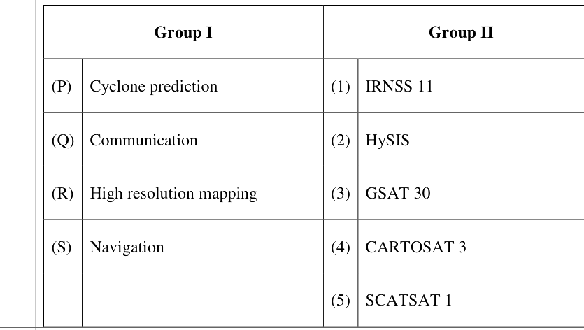
Match the application areas in Group I with the Satellites/Satellite sensors in Group II.

Question diagram

Open complete paper
9
2023 · Architecture and Planning · Data Analysis, Remote Sensing and Geo-informatics · Remote Sensing and Image Processing
Architecture and Planning (AR) 2023
Select the method(s) that can be used for landuse classification based on satellite images.
Open complete paper
10
2021 · Architecture and Planning · Data Analysis, Remote Sensing and Geo-informatics · Remote Sensing and Image Processing
Architecture and Planning (AR) 2021

Indian satellite sensor that can be used for very high resolution mapping of urban areas is

Open complete paper
11
2025 · Architecture and Planning · Data Analysis, Remote Sensing and Geo-informatics · Remote Sensing and Image Processing
Architecture and Planning (AR) 2025

Which are the two wavelength bands of light spectrum used to calculate the Normalised Difference Vegetation Index (NDVI) in remote sensing?

Open complete paper
12
2026 · Architecture and Planning · Data Analysis, Remote Sensing and Geo-informatics · Remote Sensing and Image Processing
Architecture and Planning (AR) 2026
The data type used in Digital Elevation Model (DEM) is ______.
Open complete paper
13
2026 · Architecture and Planning · Data Analysis, Remote Sensing and Geo-informatics · Remote Sensing and Image Processing
Architecture and Planning (AR) 2026
Which of the following is/are passive remote sensing technique(s)?
Open complete paper