My Cart
Your Cart 0

    Your cart is empty.

  • Total (Amount) ₹0.00
Previous year question hub

Surveying and Leveling - Soil and Water Conservation Engineering - Agricultural Engineering Previous Year Questions

Practice Surveying and Leveling - Soil and Water Conservation Engineering - Agricultural Engineering previous year questions organised from real papers, with year-wise coverage and clear topic navigation.

13Papers
13Years
16Questions
1Topics

Surveying and Leveling question pattern

Every graph below is calculated only from this selection.

Questions by year

Year-wise coverage for Surveying and Leveling. Each bar uses a separate theme-derived color.

Difficulty distribution

How the classified questions are distributed by difficulty.

Easy 12 75%
Medium 3 18.8%
Hard 1 6.3%
Question type distribution

MCQ, numerical, multiple-select and other formats found in these papers.

MCQ 13 81.3%
Numerical Answer Type (NAT) 3 18.8%

Subject weightage

Top subjects by unique question coverage.

Agricultural Engineering
16 Qs

Most asked topics

Top topics across the included previous year papers.

Soil and Water Conservation Engineering
16 Qs

Subtopic coverage

Top subtopics inside this exact selection.

Surveying and Leveling
16 Qs

Paper coverage

Question coverage for the most populated papers. Every active PYP paper remains listed below.

Agricultural Engineering (AG) 2025
1 Qs
Agricultural Engineering (AG) 2024
1 Qs
Agricultural Engineering (AG) 2023
1 Qs
Agricultural Engineering (AG) 2022
1 Qs
Agricultural Engineering (AG) 2021
1 Qs
Agricultural Engineering (AG) 2020
2 Qs
Agricultural Engineering (AG) 2018
1 Qs
Agricultural Engineering (AG) 2016
1 Qs
Agricultural Engineering (AG) 2011
1 Qs
Agricultural Engineering (AG) 2010
1 Qs
Agricultural Engineering (AG) 2009
2 Qs
Agricultural Engineering (AG) 2008
2 Qs
Agricultural Engineering (AG) 2007
1 Qs

Included previous year papers

Newest papers appear first. Sort by year, question coverage or name.

PaperYear / sessionQuestions in this viewOpen
Agricultural Engineering (AG) 202520251View paper
Agricultural Engineering (AG) 202420241View paper
Agricultural Engineering (AG) 202320231View paper
Agricultural Engineering (AG) 202220221View paper
Agricultural Engineering (AG) 202120211View paper
Agricultural Engineering (AG) 202020202View paper
Agricultural Engineering (AG) 201820181View paper
Agricultural Engineering (AG) 201620161View paper
Agricultural Engineering (AG) 201120111View paper
Agricultural Engineering (AG) 201020101View paper
Agricultural Engineering (AG) 200920092View paper
Agricultural Engineering (AG) 200820082View paper
Agricultural Engineering (AG) 200720071View paper

All Surveying and Leveling previous year questions

Practice every matching question in batches of 20, with every available option.

1
2007 · Agricultural Engineering · Soil and Water Conservation Engineering · Surveying and Leveling
Agricultural Engineering (AG) 2007
The angle between the lines AB and BC whose respective bearings are \(35^0\) and \(140^0\) is
Open complete paper
2
2008 · Agricultural Engineering · Soil and Water Conservation Engineering · Surveying and Leveling
Agricultural Engineering (AG) 2008
The area of a map plotted to a scale of 1:3000 measures 9069.37 mm². The 20 m chain used for this survey was short by 0.2 m. The true land area it represents is
Open complete paper
3
2008 · Agricultural Engineering · Soil and Water Conservation Engineering · Surveying and Leveling
Agricultural Engineering (AG) 2008

To measure the difference in level precisely between two points with a leveling instrument having collimation error, the method to be used is

Open complete paper
4
2009 · Agricultural Engineering · Soil and Water Conservation Engineering · Surveying and Leveling
Agricultural Engineering (AG) 2009

Line of sight through the leveling instrument is called

Open complete paper
5
2009 · Agricultural Engineering · Soil and Water Conservation Engineering · Surveying and Leveling
Agricultural Engineering (AG) 2009

In a reciprocal leveling, the level set up close to point P gave readings of 1.6 m and 0.8 m at stations P and Q respectively. The readings obtained by setting up the level close to point Q were 1.4 m and 0.5 m on stations P and Q respectively. Total error of collimation, curvature and refraction in m is

Open complete paper
6
2010 · Agricultural Engineering · Soil and Water Conservation Engineering · Surveying and Leveling
Agricultural Engineering (AG) 2010
A land survey is conducted on 40 m × 40 m grids and the elevations of grids in m from mean sea level are as follows.
ABC
1102.3103.0103.7
2101.5102.4102.3
3101.2103.5102.6
Assuming that cut is equal to fill, the volume of earthwork required to level the area in m3 is
Open complete paper
7
2011 · Agricultural Engineering · Soil and Water Conservation Engineering · Surveying and Leveling
Agricultural Engineering (AG) 2011
The magnetic bearing of a line at a station point is found to be 182°. The magnetic declination at the station is 3° E and the local attraction is –1° for correction. The true bearing of the line is
Open complete paper
8
2016 · Agricultural Engineering · Soil and Water Conservation Engineering · Surveying and Leveling
Agricultural Engineering (AG) 2016

The back sight of 1.258 m was observed for the bench mark (BM) at reduced level (RL) of 48 m. The corresponding fore sight on the staff held vertically inverted to the underside of a bridge beam is 4.645 m. The RL at the underside of the bridge beam in m is

Open complete paper
9
2018 · Agricultural Engineering · Soil and Water Conservation Engineering · Surveying and Leveling
Agricultural Engineering (AG) 2018

If the departure and latitude of a line during Theodolite survey are 70.03 m and -100 m, respectively, the whole circle bearing of this line in degree is

Open complete paper
10
2020 · Agricultural Engineering · Soil and Water Conservation Engineering · Surveying and Leveling
Agricultural Engineering (AG) 2020
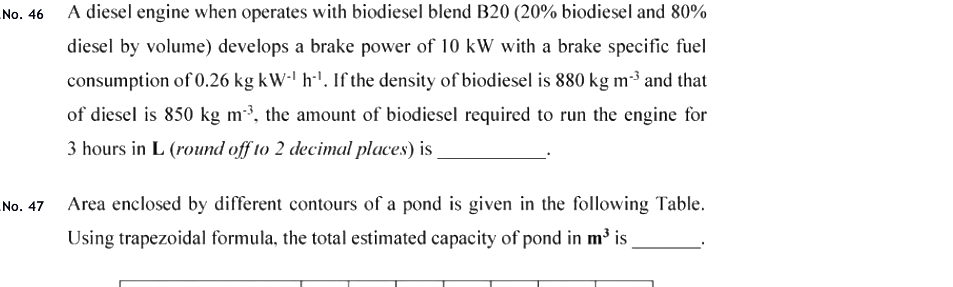
Area enclosed by different contours of a pond is given in the following Table. Using trapezoidal formula, the total estimated capacity of pond in m³ is ________.

Question diagram

Open complete paper
11
2020 · Agricultural Engineering · Soil and Water Conservation Engineering · Surveying and Leveling
Agricultural Engineering (AG) 2020
The underside beam of a railway bridge, marked as permanent Bench Mark (BM) with Reduced Level (RL) of 85.168 m, is taken as reference for leveling operation. The Back Sight (BS) on the staff held vertically inverted to the BM is 3.645 m. For the Fore Sight (FS) of 1.523 m at a point in the construction site, the RL or elevation in m is ________.
Open complete paper
12
2021 · Agricultural Engineering · Soil and Water Conservation Engineering · Surveying and Leveling
Agricultural Engineering (AG) 2021
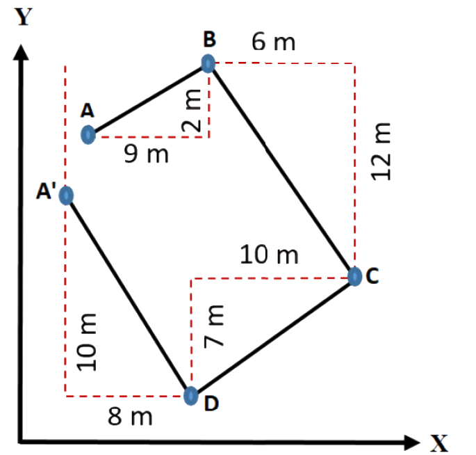
While carrying out a traverse survey ABCDA' using a theodolite with the originating station A, the departures and latitudes of the lines, as obtained, are shown in the following figure (not drawn to scale). It is seen that, due to the observational errors, the originating station A and its computed station A' are not the same. For this survey, the ‘closing error’ in m is

Question diagram

Open complete paper
13
2022 · Agricultural Engineering · Soil and Water Conservation Engineering · Surveying and Leveling
Agricultural Engineering (AG) 2022
The area of a rectangular field was measured using a 30 m survey chain, which was later found to be 5 cm short. If the length and width of the field measured using this chain were 542 m and 554 m, respectively, the true area of the field in ha is ______. [round off to two decimal places]
Open complete paper
14
2023 · Agricultural Engineering · Soil and Water Conservation Engineering · Surveying and Leveling
Agricultural Engineering (AG) 2023

If the departure and latitude of a line are 70 m and −130 m, respectively, then the whole circle bearing of the line in degrees is

Open complete paper
15
2024 · Agricultural Engineering · Soil and Water Conservation Engineering · Surveying and Leveling
Agricultural Engineering (AG) 2024
A surveyor started a longitudinal section leveling survey by taking starting bench mark of elevation 53.85 m. During the survey, he takes an observation of intermediate sight of 2.42 m with the staff held on another bench mark of 85.45 m. The sum of the back sights from the start to the point is 50.28 m and that of fore sight is 16.30 m. If the surveyor ends the survey operation on the second bench mark, the error of closure on the second bench mark, in m, is ______. (Rounded off to 2 decimal places)
Open complete paper
16
2025 · Agricultural Engineering · Soil and Water Conservation Engineering · Surveying and Leveling
Agricultural Engineering (AG) 2025

Identify the correct statement related to tape correction in chain surveying:

Open complete paper