My Cart
Your Cart 0

    Your cart is empty.

  • Total (Amount) ₹0.00
Previous year question hub

Land Surveying - Surveying and Mapping - Geomatics Engineering Previous Year Questions

Practice Land Surveying - Surveying and Mapping - Geomatics Engineering previous year questions organised from real papers, with year-wise coverage and clear topic navigation.

5Papers
5Years
57Questions
1Topics

Land Surveying question pattern

Every graph below is calculated only from this selection.

Questions by year

Year-wise coverage for Land Surveying. Each bar uses a separate theme-derived color.

Difficulty distribution

How the classified questions are distributed by difficulty.

Easy 36 63.2%
Medium 20 35.1%
Hard 1 1.8%
Question type distribution

MCQ, numerical, multiple-select and other formats found in these papers.

MCQ 36 63.2%
Numerical Answer Type (NAT) 17 29.8%
MSQ 4 7%

Subject weightage

Top subjects by unique question coverage.

Geomatics Engineering
57 Qs

Most asked topics

Top topics across the included previous year papers.

Surveying and Mapping
57 Qs

Subtopic coverage

Top subtopics inside this exact selection.

Land Surveying
57 Qs

Paper coverage

Question coverage for the most populated papers. Every active PYP paper remains listed below.

Geomatics Engineering (GE) 2026
11 Qs
Geomatics Engineering (GE) 2025
11 Qs
Geomatics Engineering (GE) 2024
13 Qs
Geomatics Engineering (GE) 2023
5 Qs
Geomatics Engineering (GE) 2022
17 Qs

Included previous year papers

Newest papers appear first. Sort by year, question coverage or name.

PaperYear / sessionQuestions in this viewOpen
Geomatics Engineering (GE) 2026202611View paper
Geomatics Engineering (GE) 2025202511View paper
Geomatics Engineering (GE) 2024202413View paper
Geomatics Engineering (GE) 202320235View paper
Geomatics Engineering (GE) 2022202217View paper

All Land Surveying previous year questions

Practice every matching question in batches of 20, with every available option.

1
2024 · Geomatics Engineering · Surveying and Mapping · Land Surveying
Geomatics Engineering (GE) 2024

A distance was measured as 200 m ± 0.1 m. The relative precision of this measurement is

Open complete paper
2
2024 · Geomatics Engineering · Surveying and Mapping · Land Surveying
Geomatics Engineering (GE) 2024
An angle is observed independently twice, and the values are as follows:
60°30'10" ± 10"
60°30'20" ± 20"
The most probable value (MPV) of the angle is
Open complete paper
3
2024 · Geomatics Engineering · Surveying and Mapping · Land Surveying
Geomatics Engineering (GE) 2024

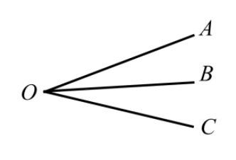
Independent angles AOB, BOC and AOC were observed as shown in figure. The standard error of all observations is same. The adjusted values of these angles using the least squares adjustment are

Source question diagram

Open complete paper
4
2024 · Geomatics Engineering · Surveying and Mapping · Land Surveying
Geomatics Engineering (GE) 2024
To reduce the slope distance (S) to an equivalent horizontal distance (H) as shown in the figure given below, the following independent observations were taken.
S = 29.95 m ± 0.01 m; θ = 4°30' ± 10'
The required precision of computed horizontal distance is ± 0.005 m. Assume a “balanced accuracy” where the contribution to precision to the horizontal distance comes equally from the slope distance and angle measurements. The minimum number of angle observations to achieve the desired precision is
(Given 1 radian = 206265 seconds)
Open complete paper
5
2024 · Geomatics Engineering · Surveying and Mapping · Land Surveying
Geomatics Engineering (GE) 2024

Change Point (CP) in levelling refers to a location where

Open complete paper
6
2024 · Geomatics Engineering · Surveying and Mapping · Land Surveying
Geomatics Engineering (GE) 2024

At a fixed instrument location in levelling, if the backsight reading at a point P is more than the foresight reading at a point Q, then

Open complete paper
7
2024 · Geomatics Engineering · Surveying and Mapping · Land Surveying
Geomatics Engineering (GE) 2024

“Transit the telescope” of a theodolite involves

Open complete paper
8
2024 · Geomatics Engineering · Surveying and Mapping · Land Surveying
Geomatics Engineering (GE) 2024

The magnetic bearing of a line in the year 1990 was found to be N 40°30' W and magnetic declination was 3°30' E. If the present magnetic declination is 2°10' W, the magnetic bearing now (in reduced bearing system) would be

Open complete paper
9
2024 · Geomatics Engineering · Surveying and Mapping · Land Surveying
Geomatics Engineering (GE) 2024

Which of the following statements is/are CORRECT?

Open complete paper
10
2024 · Geomatics Engineering · Surveying and Mapping · Land Surveying
Geomatics Engineering (GE) 2024
Consider a point A on the surface of Earth, its elevation with respect to EGM2008 (geoid) is 95.5 m. The geoidal undulation at point A is 4.5 m. The orthometric height of point A is ______ m (rounded off to one decimal place).
Open complete paper
11
2024 · Geomatics Engineering · Surveying and Mapping · Land Surveying
Geomatics Engineering (GE) 2024
The combined correction for curvature of Earth and refraction in levelling for a distance of 6 km would be ______ m (rounded off to two decimal places).
Assume the radius of earth is 6370 km.
Open complete paper
12
2024 · Geomatics Engineering · Surveying and Mapping · Land Surveying
Geomatics Engineering (GE) 2024
In tangential method of tacheometry, two vanes in a staff were fixed at a distance of 1.0 m with the bottom vane fixed at 1.0 m. The levelling staff was held vertical at a point P and the vertical angles of the vanes observed were 5°30' and 3°15', respectively. The vertical distance between the instrument axis and the bottom vane would be ______ m (rounded off to two decimal places).
Open complete paper
13
2025 · Geomatics Engineering · Surveying and Mapping · Land Surveying
Geomatics Engineering (GE) 2025
In a two-dimensional coordinate system, it is proposed to determine the size and shape of a triangle ABC in addition to its location and orientation. For this, all the internal angles and sides of the triangle were observed. Further, the planar coordinates of point A and bearing/azimuth of line AB were known. The redundancy (r) for the above system will be equal to ______ (Answer in integer).
Open complete paper
14
2025 · Geomatics Engineering · Surveying and Mapping · Land Surveying
Geomatics Engineering (GE) 2025
In a plane triangle, the observed angles \(P\), \(Q\) and \(R\), assumed uncorrelated, with given weights are:
\(P = 40^\circ19'02''\) weight = 1
\(Q = 70^\circ30'01''\) weight = 2
\(R = 69^\circ11'00''\) weight = 1
The most probable values of these angles \((\hat{P}, \hat{Q}, \hat{R})\) will be given by:
Open complete paper
15
2025 · Geomatics Engineering · Surveying and Mapping · Land Surveying
Geomatics Engineering (GE) 2025

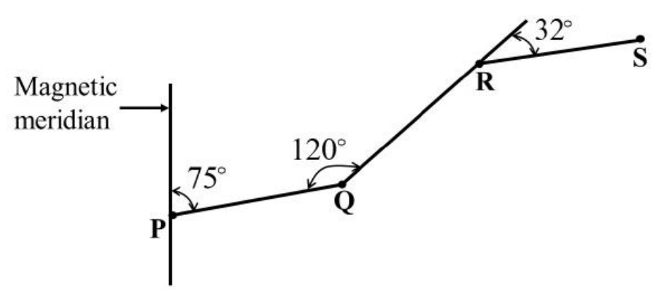
Figure below shows an open traverse PQRS, where P is the starting point of traverse and S is the end point of traverse. Which one of the following is correct?

Source question diagram

Open complete paper
16
2025 · Geomatics Engineering · Surveying and Mapping · Land Surveying
Geomatics Engineering (GE) 2025

When conducting a survey using a total station, a zenith angle is measured as 84°13'56" in the direct mode. What is the equivalent zenith angle in the reverse mode?

Open complete paper
17
2025 · Geomatics Engineering · Surveying and Mapping · Land Surveying
Geomatics Engineering (GE) 2025
In a closed traverse PQRST the following data were collected in the field. What is the correct sum of deflection angles for this traverse?
Open complete paper
18
2025 · Geomatics Engineering · Surveying and Mapping · Land Surveying
Geomatics Engineering (GE) 2025
Given \( h_P = H_P + N_P \), where \( h_P \) is the ellipsoidal/geodetic height at point \( P \), \( H_P \) is the orthometric height and \( N_P \) is the geoid undulation along the ellipsoidal normal. Which one of the following statements is correct?
Open complete paper
19
2025 · Geomatics Engineering · Surveying and Mapping · Land Surveying
Geomatics Engineering (GE) 2025
In the figure below, \( I_1 \) and \( I_2 \) are the two instrument stations. The instrument stations and the object (P) lie in the same vertical plane. Assume all instruments and staff are levelled.
\( L \) = horizontal distance between the object and the station \( I_2 \)
\( b \) = horizontal distance between the instrument stations
\( S \) = staff reading at the Benchmark (BM) for horizontal line of sight
\( H \) = reading on the staff at P
\( r \) = height of the point sighted by instruments at the staff kept at P from the line of sight of the instruments
\( \alpha_1 \) and \( \alpha_2 \) = vertical angles to the reading on staff at P from \( I_1 \) and \( I_2 \), respectively
Which one of the following relationships is correct for \( L \)?
Open complete paper
20
2025 · Geomatics Engineering · Surveying and Mapping · Land Surveying
Geomatics Engineering (GE) 2025

In a closed traversed with five sides, the closing error found from the fore bearing and back bearing of the last line is +0.5°. The correction to the fourth line will be

Open complete paper

Showing 20 of 56 questions