My Cart
Your Cart 0

    Your cart is empty.

  • Total (Amount) ₹0.00
Previous year question hub

Aerial Photogrammetry - Surveying and Mapping - Geomatics Engineering Previous Year Questions

Practice Aerial Photogrammetry - Surveying and Mapping - Geomatics Engineering previous year questions organised from real papers, with year-wise coverage and clear topic navigation.

5Papers
5Years
33Questions
1Topics

Aerial Photogrammetry question pattern

Every graph below is calculated only from this selection.

Questions by year

Year-wise coverage for Aerial Photogrammetry. Each bar uses a separate theme-derived color.

Difficulty distribution

How the classified questions are distributed by difficulty.

Easy 21 63.6%
Medium 12 36.4%

Question type distribution

MCQ, numerical, multiple-select and other formats found in these papers.

MCQ 18 54.5%
Numerical Answer Type (NAT) 11 33.3%
MSQ 4 12.1%

Subject weightage

Top subjects by unique question coverage.

Geomatics Engineering
33 Qs

Most asked topics

Top topics across the included previous year papers.

Surveying and Mapping
33 Qs

Subtopic coverage

Top subtopics inside this exact selection.

Aerial Photogrammetry
33 Qs

Paper coverage

Question coverage for the most populated papers. Every active PYP paper remains listed below.

Geomatics Engineering (GE) 2026
8 Qs
Geomatics Engineering (GE) 2025
6 Qs
Geomatics Engineering (GE) 2024
9 Qs
Geomatics Engineering (GE) 2023
5 Qs
Geomatics Engineering (GE) 2022
5 Qs

Included previous year papers

Newest papers appear first. Sort by year, question coverage or name.

PaperYear / sessionQuestions in this viewOpen
Geomatics Engineering (GE) 202620268View paper
Geomatics Engineering (GE) 202520256View paper
Geomatics Engineering (GE) 202420249View paper
Geomatics Engineering (GE) 202320235View paper
Geomatics Engineering (GE) 202220225View paper

All Aerial Photogrammetry previous year questions

Practice every matching question in batches of 20, with every available option.

1
2024 · Geomatics Engineering · Surveying and Mapping · Aerial Photogrammetry
Geomatics Engineering (GE) 2024

The approximate altitude (above earth surface) of polar sun-synchronous orbits of ISRO’s remote sensing satellites is

Open complete paper
2
2024 · Geomatics Engineering · Surveying and Mapping · Aerial Photogrammetry
Geomatics Engineering (GE) 2024

Which of the following statements is/are CORRECT?

Open complete paper
3
2024 · Geomatics Engineering · Surveying and Mapping · Aerial Photogrammetry
Geomatics Engineering (GE) 2024

Using the following data, the spatial resolution of a push-broom sensor is _____ m (in integer).

Data:
Orbital altitude (above earth surface) = 1000 km
Number of spectral bands = 5
Number of detectors/CCDs (charged coupled devices) in a row = 4000
Ground swath = 20 km

Open complete paper
4
2024 · Geomatics Engineering · Surveying and Mapping · Aerial Photogrammetry
Geomatics Engineering (GE) 2024

Scale of a vertical aerial photograph of an undulating terrain is

Open complete paper
5
2024 · Geomatics Engineering · Surveying and Mapping · Aerial Photogrammetry
Geomatics Engineering (GE) 2024

Isocentre of a tilted photograph is

Open complete paper
6
2024 · Geomatics Engineering · Surveying and Mapping · Aerial Photogrammetry
Geomatics Engineering (GE) 2024
If the longitudinal overlap in aerial photographs is kept as 65%, the common overlap (superlap) between three successive photographs is ______ % (in integer).
Open complete paper
7
2024 · Geomatics Engineering · Surveying and Mapping · Aerial Photogrammetry
Geomatics Engineering (GE) 2024
A line measures 15 cm on an aerial photograph, while it measures 5 cm on a map at 1:24000 scale. The photograph was taken using a camera lens of 20 cm focal length. Average elevation of terrain is 240 m above mean sea level. The flying height of the aircraft above mean sea level is ______ m (in integer).
Open complete paper
8
2024 · Geomatics Engineering · Surveying and Mapping · Aerial Photogrammetry
Geomatics Engineering (GE) 2024
A high tower appeared on an aerial photograph taken at 1000 m above mean sea level with a camera lens of 15 cm focal length. The radial distances of the top and bottom images of the tower from principal point of photograph are 92.6 mm and 78.3 mm, respectively. If the average elevation of terrain is 300 m above mean sea level, then the height of the tower above ground is ______ m (rounded off to the nearest integer).
Open complete paper
9
2024 · Geomatics Engineering · Surveying and Mapping · Aerial Photogrammetry
Geomatics Engineering (GE) 2024
In spatial interpolation using coordinate transformations for image-to-map rectification, the minimum number of ground control points (GCPs) required to perform a third-order transformation is ______ (in integer).
Open complete paper
10
2025 · Geomatics Engineering · Surveying and Mapping · Aerial Photogrammetry
Geomatics Engineering (GE) 2025

Which one of the following parameters does NOT affect the scale of a vertical aerial photograph?

Open complete paper
11
2025 · Geomatics Engineering · Surveying and Mapping · Aerial Photogrammetry
Geomatics Engineering (GE) 2025

Select the correct statement in the context of relief displacement in vertical aerial photographs.

Open complete paper
12
2025 · Geomatics Engineering · Surveying and Mapping · Aerial Photogrammetry
Geomatics Engineering (GE) 2025
Consider a pair of overlapping vertical aerial photographs taken from a flying height of 665 m above a point A on the ground, with a camera having a focal length of 152.4 mm. The height of the point A above the mean sea level is 535 m. The parallax bar reading of the point A as measured from the photographs is 10.96 mm. Assuming the air base to be 400 m, the parallax bar constant is ________ mm.
Open complete paper
13
2025 · Geomatics Engineering · Surveying and Mapping · Aerial Photogrammetry
Geomatics Engineering (GE) 2025

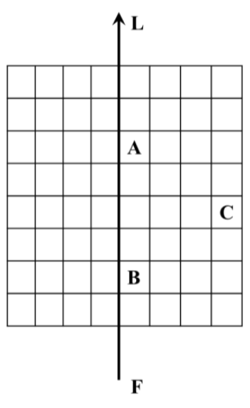
Consider an infinitely sized square grid pattern (as shown in the figure below) overlaid on a flat ground at an elevation of 120 m above mean sea level. An image is taken by a camera from flying height of 450 m above mean sea level. Assume that the flying height remains constant throughout the operation of the flight. The flying direction is along the line FL, as shown in the figure below. The camera is looking in the off-nadir in the flight direction resulting in a low oblique photograph. Which of the following statements for the resulting low oblique photograph is/are correct?

Source question diagram

Open complete paper
14
2025 · Geomatics Engineering · Surveying and Mapping · Aerial Photogrammetry
Geomatics Engineering (GE) 2025
A 23 cm square format camera with a focal length of 152.4 mm is used for taking vertical aerial photographs with 60% end-lap. These photographs are viewed under a stereoscope with a base-height ratio of 0.15. The vertical exaggeration while stereoviewing these photographs is______ .(Answer in integer).
Open complete paper
15
2025 · Geomatics Engineering · Surveying and Mapping · Aerial Photogrammetry
Geomatics Engineering (GE) 2025

Which of the following statements is/are correct regarding across-track scanning sensor of an airborne optical imaging system?

Open complete paper
16
2022 · Geomatics Engineering · Surveying and Mapping · Aerial Photogrammetry
Geomatics Engineering (GE) 2022

The camera axis of an aerial camera is defined as

Open complete paper
17
2022 · Geomatics Engineering · Surveying and Mapping · Aerial Photogrammetry
Geomatics Engineering (GE) 2022
Select the INCORRECT statement:
Open complete paper
18
2022 · Geomatics Engineering · Surveying and Mapping · Aerial Photogrammetry
Geomatics Engineering (GE) 2022
The parallax of a point 'a' on a pair of successive overlapping photographs is 73.22 mm and the micrometer reading of a parallax bar of point 'a' is 12.10 mm. Similarly, the micrometer reading of the parallax bar of point 'b' is 9.65 mm, then the parallax of the point 'b' is ______ mm (round off to 2 decimal places).
Open complete paper
19
2022 · Geomatics Engineering · Surveying and Mapping · Aerial Photogrammetry
Geomatics Engineering (GE) 2022
The scale of an aerial photograph is 5 mm = 100 m. The size of the photograph is 23 cm × 23 cm. If the longitudinal overlap is 65% and sidelap is 20%, the number of photographs required to cover an area of 12.5 km × 8 km is ______ (in integer). Given that the flight line is along the longer dimension.
Open complete paper
20
2022 · Geomatics Engineering · Surveying and Mapping · Aerial Photogrammetry
Geomatics Engineering (GE) 2022
The FOV of a sensor (for a scene) placed at a nadir height of 6 km is 90 degree. The ground swath width of the scene is ______ km (in integer).
Open complete paper

Showing 20 of 33 questions