My Cart
Your Cart 0

    Your cart is empty.

  • Total (Amount) ₹0.00
Previous year question hub

Image Transformation - Image Processing and Analysis - Geomatics Engineering Previous Year Questions

Practice Image Transformation - Image Processing and Analysis - Geomatics Engineering previous year questions organised from real papers, with year-wise coverage and clear topic navigation.

3Papers
3Years
8Questions
1Topics

Image Transformation question pattern

Every graph below is calculated only from this selection.

Questions by year

Year-wise coverage for Image Transformation. Each bar uses a separate theme-derived color.

Difficulty distribution

How the classified questions are distributed by difficulty.

Medium 5 62.5%
Easy 3 37.5%

Question type distribution

MCQ, numerical, multiple-select and other formats found in these papers.

MSQ 4 50%
MCQ 3 37.5%
Numerical Answer Type (NAT) 1 12.5%

Subject weightage

Top subjects by unique question coverage.

Geomatics Engineering
8 Qs

Most asked topics

Top topics across the included previous year papers.

Image Processing and Analysis
8 Qs

Subtopic coverage

Top subtopics inside this exact selection.

Image Transformation
8 Qs

Paper coverage

Question coverage for the most populated papers. Every active PYP paper remains listed below.

Geomatics Engineering (GE) 2025
1 Qs
Geomatics Engineering (GE) 2024
4 Qs
Geomatics Engineering (GE) 2022
3 Qs

Included previous year papers

Newest papers appear first. Sort by year, question coverage or name.

PaperYear / sessionQuestions in this viewOpen
Geomatics Engineering (GE) 202520251View paper
Geomatics Engineering (GE) 202420244View paper
Geomatics Engineering (GE) 202220223View paper

All Image Transformation previous year questions

Practice every matching question in batches of 20, with every available option.

1
2024 · Geomatics Engineering · Image Processing and Analysis · Image Transformation
Geomatics Engineering (GE) 2024
_____ is a raster image resampling technique that DOES NOT alter any of the output cell values from the input raster dataset.
Open complete paper
2
2024 · Geomatics Engineering · Image Processing and Analysis · Image Transformation
Geomatics Engineering (GE) 2024

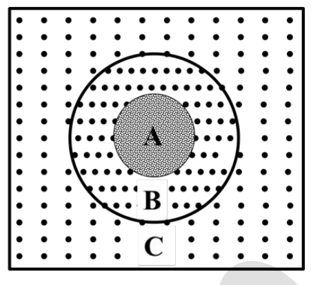
The figure given below shows the Fourier spectrum obtained by applying filter on a remote sensing image in frequency domain. Zone A represents the location of _____ components.

Source question diagram

Open complete paper
3
2024 · Geomatics Engineering · Image Processing and Analysis · Image Transformation
Geomatics Engineering (GE) 2024

Which of the following statements about Principal Component Analysis (PCA) is/are CORRECT?

Open complete paper
4
2024 · Geomatics Engineering · Image Processing and Analysis · Image Transformation
Geomatics Engineering (GE) 2024

Which of the following statements about image ratio is/are CORRECT?

Open complete paper
5
2025 · Geomatics Engineering · Image Processing and Analysis · Image Transformation
Geomatics Engineering (GE) 2025
The hue, intensity and saturation values for a pixel are \( H = 0.5 \) rad, \( S = 0.5 \) and \( I = 0.3 \), respectively. If the pixel is converted to RGB color model, then the value of the green pixel would be _____ (rounded off to 2 decimal places).
Open complete paper
6
2022 · Geomatics Engineering · Image Processing and Analysis · Image Transformation
Geomatics Engineering (GE) 2022
In case of Principal Component Analysis (PCA), the variance of a single variable expresses the spread of its values about the
Open complete paper
7
2022 · Geomatics Engineering · Image Processing and Analysis · Image Transformation
Geomatics Engineering (GE) 2022

Choose the CORRECT statement(s).

Open complete paper
8
2022 · Geomatics Engineering · Image Processing and Analysis · Image Transformation
Geomatics Engineering (GE) 2022

Band ratio in satellite images interpretation is applied to

Open complete paper