My Cart
Your Cart 0

    Your cart is empty.

  • Total (Amount) ₹0.00
Previous year question hub

GIS - Common Section - Geomatics Engineering Previous Year Questions

Practice GIS - Common Section - Geomatics Engineering previous year questions organised from real papers, with year-wise coverage and clear topic navigation.

5Papers
5Years
25Questions
1Topics

GIS question pattern

Every graph below is calculated only from this selection.

Questions by year

Year-wise coverage for GIS. Each bar uses a separate theme-derived color.

Difficulty distribution

How the classified questions are distributed by difficulty.

Easy 20 80%
Medium 5 20%

Question type distribution

MCQ, numerical, multiple-select and other formats found in these papers.

MCQ 20 80%
MSQ 5 20%

Subject weightage

Top subjects by unique question coverage.

Geomatics Engineering
25 Qs

Most asked topics

Top topics across the included previous year papers.

Common Section
25 Qs

Subtopic coverage

Top subtopics inside this exact selection.

GIS
25 Qs

Paper coverage

Question coverage for the most populated papers. Every active PYP paper remains listed below.

Geomatics Engineering (GE) 2026
5 Qs
Geomatics Engineering (GE) 2025
8 Qs
Geomatics Engineering (GE) 2024
6 Qs
Geomatics Engineering (GE) 2023
2 Qs
Geomatics Engineering (GE) 2022
4 Qs

Included previous year papers

Newest papers appear first. Sort by year, question coverage or name.

PaperYear / sessionQuestions in this viewOpen
Geomatics Engineering (GE) 202620265View paper
Geomatics Engineering (GE) 202520258View paper
Geomatics Engineering (GE) 202420246View paper
Geomatics Engineering (GE) 202320232View paper
Geomatics Engineering (GE) 202220224View paper

All GIS previous year questions

Practice every matching question in batches of 20, with every available option.

1
2024 · Geomatics Engineering · Common Section · GIS
Geomatics Engineering (GE) 2024

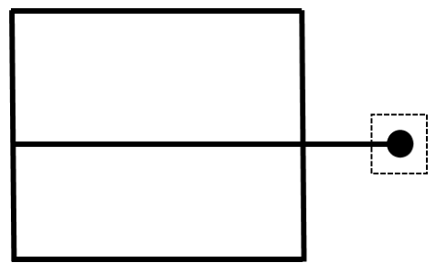
Identify the type of digitizing error in the following figure.

Source question diagram

Open complete paper
2
2024 · Geomatics Engineering · Common Section · GIS
Geomatics Engineering (GE) 2024

Which of the following is NOT a derivative of digital elevation model (DEM)?

Open complete paper
3
2024 · Geomatics Engineering · Common Section · GIS
Geomatics Engineering (GE) 2024

Which of the following is a core vector GIS operation?

Open complete paper
4
2024 · Geomatics Engineering · Common Section · GIS
Geomatics Engineering (GE) 2024

Which of the following statements is/are CORRECT?

Open complete paper
5
2024 · Geomatics Engineering · Common Section · GIS
Geomatics Engineering (GE) 2024

In GIS, buffer is a zone with a specified width surrounding a spatial feature. Which of the following statements regarding buffer is/are CORRECT?

Open complete paper
6
2024 · Geomatics Engineering · Common Section · GIS
Geomatics Engineering (GE) 2024

Which of the following statements is/are INCORRECT in the context of GIS?

Open complete paper
7
2025 · Geomatics Engineering · Common Section · GIS
Geomatics Engineering (GE) 2025

Which one of the following statements is NOT correct in the context of Geographic Information System?

Open complete paper
8
2025 · Geomatics Engineering · Common Section · GIS
Geomatics Engineering (GE) 2025

Which one of the following statements is NOT correct in the context of shapefile?

Open complete paper
9
2025 · Geomatics Engineering · Common Section · GIS
Geomatics Engineering (GE) 2025
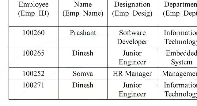
The table below is an attribute table about employee records. Which attribute can be used as a primary key?

Question diagram

Open complete paper
10
2025 · Geomatics Engineering · Common Section · GIS
Geomatics Engineering (GE) 2025
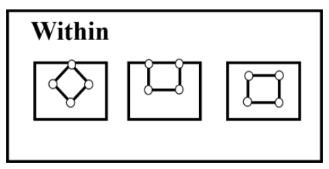
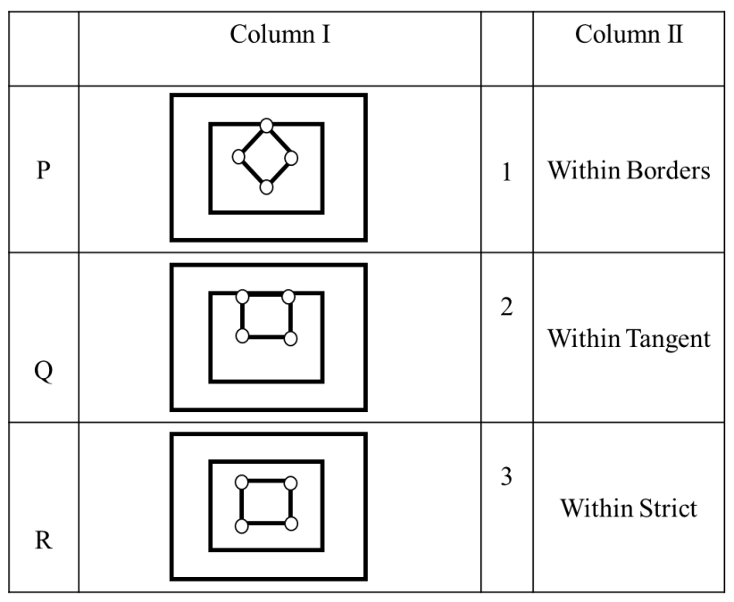
Find the best match between column I and column II for the following scenario related to spatial operators.

Source question diagram

Source question diagram

Open complete paper
11
2025 · Geomatics Engineering · Common Section · GIS
Geomatics Engineering (GE) 2025
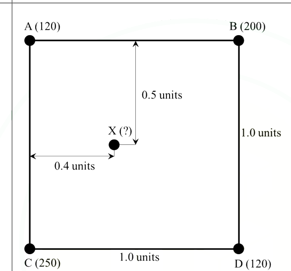
Consider the nodes of a square grid A, B, C and D (shown in figure below), where a certain parameter is measured. The distances between the points is also indicated in the same figure. For example, the value observed at point A is 120 and is indicated as A (120), and the distance between points A and B is 1.0 units. The value at point ‘X’ computed using bilinear interpolation, using the values at points A, B, C and D is ______.

Question diagram

Open complete paper
12
2025 · Geomatics Engineering · Common Section · GIS
Geomatics Engineering (GE) 2025
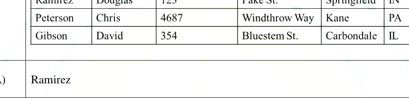
The first value in the output of a SQL query (given below) when run on a table having name “Table-1” is? SQL Query: SELECT LastName FROM Table-1 WHERE State=“IN” ORDER BY FirstName

Question diagram

Open complete paper
13
2025 · Geomatics Engineering · Common Section · GIS
Geomatics Engineering (GE) 2025

In a Geographic Information System database, a stream is represented by a line and houses are represented by polygons. The pollution in the stream is affecting houses within a distance of 500 m on both sides. Which vector data analysis operations should be performed to identify houses affected by the pollution in the stream?

Open complete paper
14
2025 · Geomatics Engineering · Common Section · GIS
Geomatics Engineering (GE) 2025

Which of the following statements is/are correct in the context of Voronoi polygon?

Open complete paper
15
2022 · Geomatics Engineering · Common Section · GIS
Geomatics Engineering (GE) 2022
In GIS database, which type of attribute may be used to represent area?
Open complete paper
16
2022 · Geomatics Engineering · Common Section · GIS
Geomatics Engineering (GE) 2022

What is attribute uncertainty?

Open complete paper
17
2022 · Geomatics Engineering · Common Section · GIS
Geomatics Engineering (GE) 2022
In GIS, ______ triangulation is a proximal method that satisfies the requirement that a circle drawn through the three nodes of a triangle contains no other node.
Open complete paper
18
2022 · Geomatics Engineering · Common Section · GIS
Geomatics Engineering (GE) 2022

In GIS, reclassification is performed to

Open complete paper
19
2023 · Geomatics Engineering · Common Section · GIS
Geomatics Engineering (GE) 2023
Which vector data analysis tool combines geometries and attributes from different layers?
Open complete paper
20
2023 · Geomatics Engineering · Common Section · GIS
Geomatics Engineering (GE) 2023
Match the following errors (Column 1) in spatial data digitization with their descriptions (Column 2).
Column 1Column 2
(P) Mis-located entities1) Points, lines or boundary segments digitized twice
(Q) Missing labels2) Points, lines or boundary segments digitized in wrong place
(R) Artefacts of digitization3) Undershoots, overshoots, wrongly placed nodes loops or spikes
(S) Duplicate labels4) Undefined polygons
(T) Duplicate entities5) Two or more identification labels for same polygon
Open complete paper

Showing 20 of 25 questions