My Cart
Your Cart 0

    Your cart is empty.

  • Total (Amount) ₹0.00
Previous year question hub

Remote Sensing - Advanced topics in Geology - Geology & Geophysics Previous Year Questions

Practice Remote Sensing - Advanced topics in Geology - Geology & Geophysics previous year questions organised from real papers, with year-wise coverage and clear topic navigation.

10Papers
10Years
11Questions
1Topics

Remote Sensing question pattern

Every graph below is calculated only from this selection.

Questions by year

Year-wise coverage for Remote Sensing. Each bar uses a separate theme-derived color.

Difficulty distribution

How the classified questions are distributed by difficulty.

Easy 6 54.5%
Medium 5 45.5%

Question type distribution

MCQ, numerical, multiple-select and other formats found in these papers.

MCQ 6 54.5%
Numerical Answer Type (NAT) 3 27.3%
Fill in the blanks 2 18.2%

Subject weightage

Top subjects by unique question coverage.

Geology & Geophysics
11 Qs

Most asked topics

Top topics across the included previous year papers.

Advanced topics in Geology
11 Qs

Subtopic coverage

Top subtopics inside this exact selection.

Remote Sensing
11 Qs

Paper coverage

Question coverage for the most populated papers. Every active PYP paper remains listed below.

Geology & Geophysics (GG) 2025 [Session 1]
1 Qs
Geology & Geophysics (GG) 2023 [Session 1]
1 Qs
Geology & Geophysics (GG) 2020
1 Qs
Geology & Geophysics (GG) 2019
1 Qs
Geology & Geophysics (GG) 2018
1 Qs
Geology & Geophysics (GG) 2017
1 Qs
Geology & Geophysics (GG) 2016
1 Qs
Geology & Geophysics (GG) 2014
1 Qs
Geology & Geophysics (GG) 2012
2 Qs
Geology & Geophysics (GG) 2010
1 Qs

Included previous year papers

Newest papers appear first. Sort by year, question coverage or name.

PaperYear / sessionQuestions in this viewOpen
Geology & Geophysics (GG) 2025 [Session 1]20251View paper
Geology & Geophysics (GG) 2023 [Session 1]20231View paper
Geology & Geophysics (GG) 202020201View paper
Geology & Geophysics (GG) 201920191View paper
Geology & Geophysics (GG) 201820181View paper
Geology & Geophysics (GG) 201720171View paper
Geology & Geophysics (GG) 201620161View paper
Geology & Geophysics (GG) 201420141View paper
Geology & Geophysics (GG) 201220122View paper
Geology & Geophysics (GG) 201020101View paper

All Remote Sensing previous year questions

Practice every matching question in batches of 20, with every available option.

1
2010 · Geology & Geophysics · Advanced topics in Geology · Remote Sensing
Geology & Geophysics (GG) 2010

The spatial resolution of IRS LISS-III multi-spectral sensor for Near Infra-Red (NIR) band is

Open complete paper
2
2012 · Geology & Geophysics · Advanced topics in Geology · Remote Sensing
Geology & Geophysics (GG) 2012

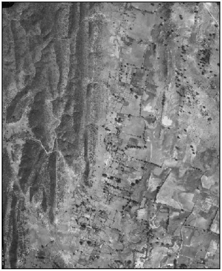
Identify the type of fault present in the given aerial photograph.

Source question diagram

Open complete paper
3
2012 · Geology & Geophysics · Advanced topics in Geology · Remote Sensing
Geology & Geophysics (GG) 2012

A major thrust in the Himalayas has resulted in intense shearing of a zone about 0.5 km wide on either side of the thrust leading to landslides. Which GIS function can be used to display the shear zone?

Open complete paper
4
2014 · Geology & Geophysics · Advanced topics in Geology · Remote Sensing
Geology & Geophysics (GG) 2014
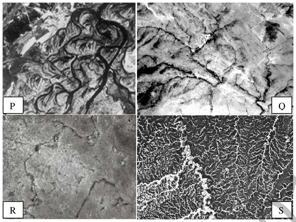
Drainage patterns observed in four areas are shown in black-and-white panchromatic images P, Q, R and S. Field work in these areas has indicated presence of the following lithology/geological unit. 1. Fractured quartzite 2. Shale 3. Limestone 4. Alluvial plain The correct match of the drainage patterns with the lithology/geological unit is

Source question diagram

Open complete paper
5
2016 · Geology & Geophysics · Advanced topics in Geology · Remote Sensing
Geology & Geophysics (GG) 2016
Clay minerals and Fe-oxide minerals, products of hydrothermal alteration and supergene oxidation, are good indicators of mineralization. Choose the CORRECT Thematic Mapper (TM) band ratio images for detection of these minerals.
Open complete paper
6
2025 · Geology & Geophysics · Advanced topics in Geology · Remote Sensing
Geology & Geophysics (GG) 2025 [Session 1]
If the lowest Digital Number (DN) value in an image of 10-bit radiometric resolution is 0, then the maximum DN value of that image is ______
(Answer in integer)
Open complete paper
7
2017 · Geology & Geophysics · Advanced topics in Geology · Remote Sensing
Geology & Geophysics (GG) 2017
In a vertical aerial photo, the top and bottom of a tower built on a flat terrain is displaced by 2 mm. In the photograph, the distance between top of the tower and nadir point is 100 mm. The flying height of the aircraft was 3000 m above the ground. The estimated height of the tower is __________ m.
Open complete paper
8
2018 · Geology & Geophysics · Advanced topics in Geology · Remote Sensing
Geology & Geophysics (GG) 2018
A sun synchronous satellite is at an altitude of 300 km and the spectrometer makes an angular coverage angle of 12°. The Swath (GFOV) of the satellite is ________ km.
Open complete paper
9
2019 · Geology & Geophysics · Advanced topics in Geology · Remote Sensing
Geology & Geophysics (GG) 2019
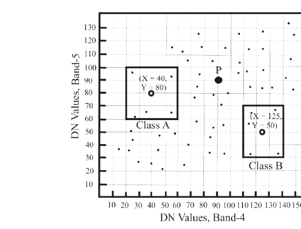
The figure given below represents a scatter plot of Digital Numbers (DN) of Band 4 and Band 5 of a satellite imagery. The fields of Class A and Class B are indicated by the rectangular boxes along with their class means (open circles). Class assignment for the point P by Minimum Distance to Mean (MDM) and Nearest Neighbour (NN) algorithms are ______.

Question diagram

Open complete paper
10
2020 · Geology & Geophysics · Advanced topics in Geology · Remote Sensing
Geology & Geophysics (GG) 2020
The scale factor of an aerial photo of a planar ground surface, taken vertically downwards by a camera with a focal length of 300 mm, from a flying height of 3000 m is ______.
Open complete paper
11
2023 · Geology & Geophysics · Advanced topics in Geology · Remote Sensing
Geology & Geophysics (GG) 2023 [Session 1]
A vertical aerial photograph is obtained over flat terrain with a 30 cm focal-length camera lens from an altitude of 18288 m. If the width of a dolerite dyke on this vertical photograph is 2 mm, its actual width on the terrain is ___________ m. [round off to 2 decimal places]
Open complete paper